How to Manage Risk Areas
I. Function Introduction
Risk area management achieves the following by identifying and classifying risks in production sites and dividing them into spatial ranges with specific risk levels:
- Risk Visualization: Four-color labeling to intuitively display risk distribution
- Grid Management: Dividing areas into manageable units
- Precision Control: Implementing differentiated measures for different risk levels
- Dynamic Monitoring: Real-time updates of risk status changes
Core Value:
- Enhance risk perception capabilities
- Optimize resource allocation
- Strengthen control of key areas
- Support emergency decision-making
Legal Basis:
- 《General Rules for Safety Production Risk Classification and Control System》(GB/T 33000)
- 《Basic Norms for Enterprise Safety Production Standardization》(GB/T 33000)
Access Entry:
- Administrator logs into management backend
- Navigation menu select: 【Risk Identification】→【Risk Areas】
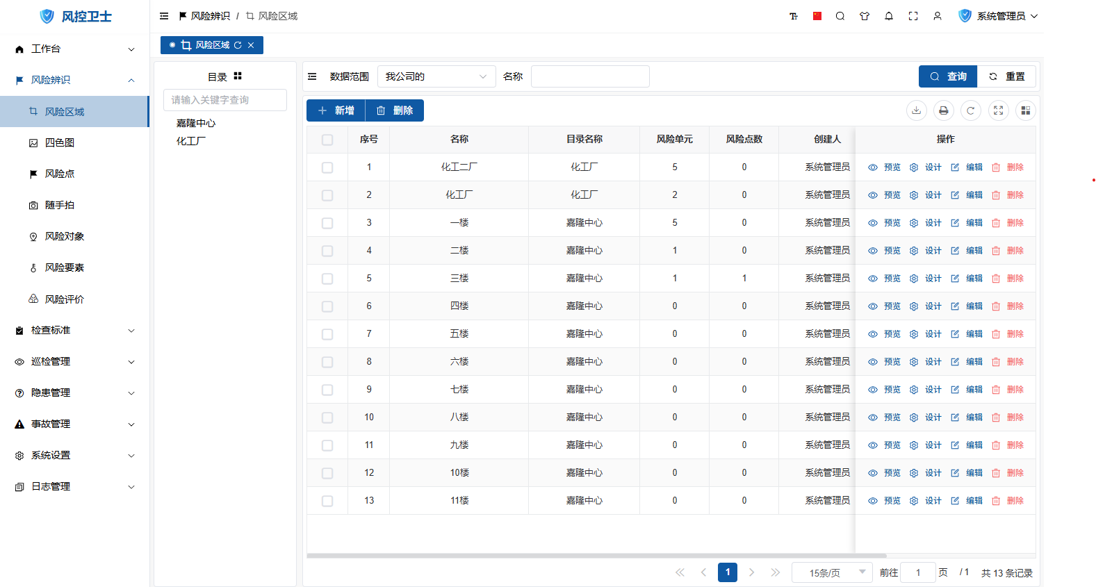
II. Add Risk Area
Operation Steps:
- Click "New" button on toolbar
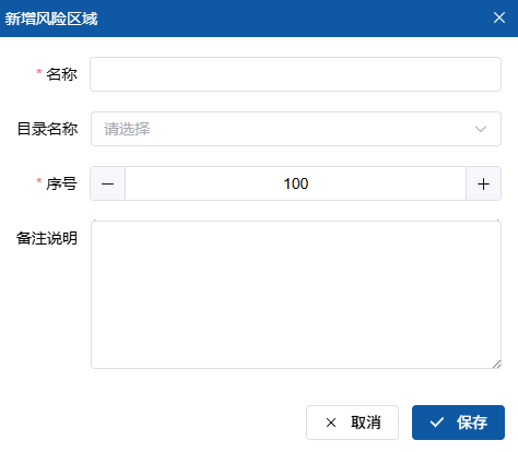
Fill in key information:
- Area Name (Required, e.g. "Production Workshop 1")
- Category (Classification management)
- Remarks (Area description)
Click "Save" to complete creation
Precautions:
- Area names must be unique and non-repeatable
- Recommended to draw area boundary diagrams
III. Modify Risk Area
Operation Steps:
- Locate target area
- Click
 edit button in operation column
 - Modify:
- Area Name (Required, e.g. "Production Workshop 1")
- Category (Classification management)
- Remarks (Area description)
- Click "Save" to submit
IV. Delete Risk Area
Operation Steps:
- Locate target area
- Click
 delete button in operation column
 - Confirm deletion operation
Deletion Restrictions:
- Areas with risk points cannot be deleted
- Areas with historical inspection records cannot be deleted
V. Risk Four-color Map Management
1. Function Description
The risk four-color map is a core tool for risk visualization:
- Level Identification: Red/Orange/Yellow/Blue four-color labeling for risk levels
- Grid Management: Dividing areas into manageable units
- Dynamic Updates: Real-time reflection of risk status changes
Level Standards:
| Color | Risk Level | Control Requirements |
|---|---|---|
| Red | Major Risk | Immediate rectification, real-time monitoring |
| Orange | High Risk | Rectification within time limit, key monitoring |
| Yellow | Medium Risk | Routine control, regular inspection |
| Blue | Low Risk | Daily monitoring, self-management |
2. Four-color Map Editor
Access Path:
- Locate target area
- Click "Design" button in operation column
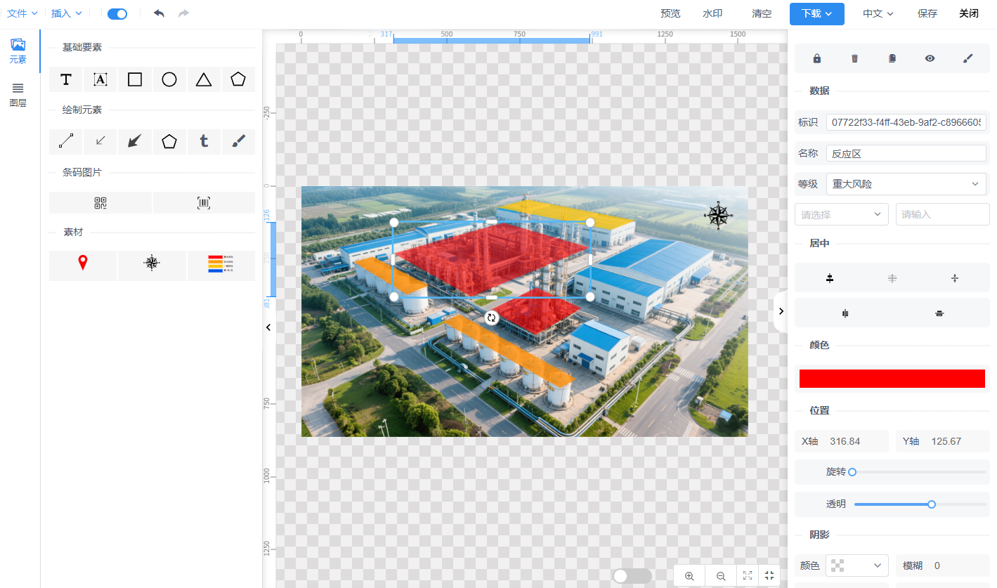
3. Operation Guide
| Function | Operation Steps | Icon | Requirements |
|---|---|---|---|
| Insert Base Map | 1. Click "Insert" > "Insert Image" 2. Select plant layout/aerial photo | Resolution ≥300dpi | |
| Draw Risk Unit | 1. Select  polygon tool polygon tool2. Click to draw closed area 3. Set properties: - Name - Risk Level | | Unit area ≤500㎡ |
| Add Risk Point | 1. Select  risk point icon risk point icon2. Drag to accurate position 3. Set properties: - Code - Name - Risk Level | | Code must be unique |
| Direction Indicator | 1. Select  direction icon direction icon2. Place in corner of drawing | | Label "North-South Orientation" |
| Add Legend | 1. Select  legend icon legend icon2. Place in suitable position 3. Edit legend content | | Include four-color level description |
| Delete Element | Right-click target element and select "Delete" | Confirm before deletion |
4. Design Standards
- Base Map Requirements:
- Use latest plant layout
- Scale 1:500-1:1000
- Include main reference objects
- Unit Division:
- Divide grids by functional area
- Single grid ≤500㎡
- Clear boundaries without overlap
- Labeling Standards:
- Unique risk point codes
- Use unified legend symbols
- Mark evacuation routes
VI. Best Practices
1. Design Principles
- Risk-Oriented: Highlight key high-risk areas
- Practicality First: Ensure on-site recognizability
- Dynamic Updates: Quarterly risk status updates
- Full Participation: Train employees in map reading
2. Application Scenarios
| Scenario | Application Method | Effect |
|---|---|---|
| Daily Inspection | Plan routes according to four-color map | Prioritize inspection of high-risk areas |
| Emergency Response | Quickly locate risk points | Shorten emergency response time |
| Safety Training | Visual risk education | Improve risk awareness |
| Contractor Management | Mark dangerous operation areas | Strengthen external personnel control |